Connecting People and Landscape: Integrating Cultural Landscapes, Climate Resiliency, and Growth Management in the Low Country
Honor Award
Analysis and Planning
Beaufort County, South Carolina, United States
Design Workshop, Inc.
Client: Beaufort County and Beaufort County Rural and Critical Lands Preservation Program
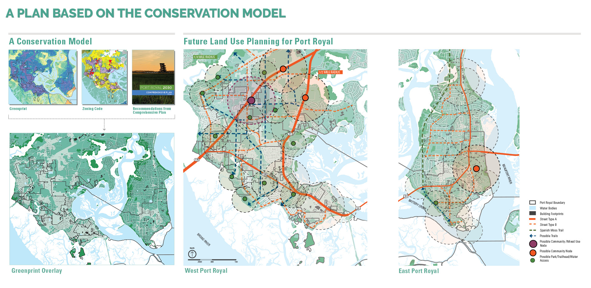

The Greenprint Plan and Comprehensive Plan create a framework—informed by community input and priorities—for data-driven land use planning and open space conservation and tools to guide the growth of the county in conservation-oriented development. They promote strategies for housing affordability, multimodal transportation, and place-based character, such as compact transit-ready nodes, hamlets, and villages. The jury praised the project as being an excellent planning effort with a wonderful use of graphics.
- 2022 Awards Jury
Project Credits
Kurt Culbertson, FASLA, Principal - Design Workshop, Inc.
Emily McCoy, ASLA, Principal - Design Workshop, Inc.
Glenn Walters, Lindsey Naylor, Adeline Lerner, Brenna Laffey, Urey Zhuang, Corey Dodd, Shaoyu Chen, Designer - Design Workshop, Inc.
Project Statement
The impacts of sea level rise and population growth threaten Beaufort County, South Carolina’s cultural landscapes, visual resources, wet and dry ecosystems, historically black communities, working waterfronts, and agricultural landscapes. Two companion documents, the 2020 Beaufort County Greenprint Plan and the 2040 Comprehensive Plan for Beaufort County:
1. Achieved statistically relevant community engagement response during the height of Covid -19 restrictions using robust and innovative storytelling techniques.
2. Elevated the discourse around climate change resiliency in a politically conservative county and created adopted plans.
3. Outlines an ecological approach to land use that considers sea level rise, land and water wildlife habitat, visual resources, heritage trees, and cultural landscapes.
4. Creates a model for the country that integrates climate change with future growth modeling and coordinates for the first time an overall land conservation strategy that uses ecology and landscape as the primary driver for growth management.
5. Incorporates strategies for placemaking, affordable housing, transit-ready development, trails, blueways, and walkability in a county that has been reluctant to address these issues.
Project Narrative
ECOLOGICAL AND CULTURAL LANDSCAPES OF THE LOW COUNTRY
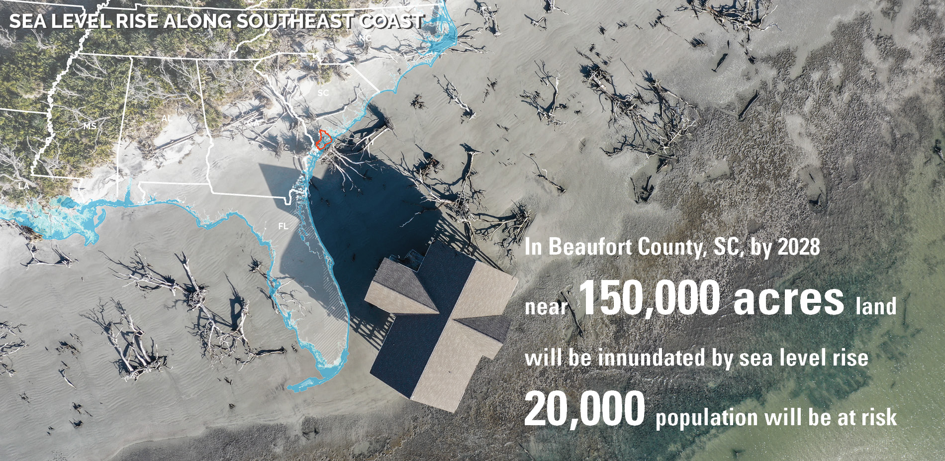
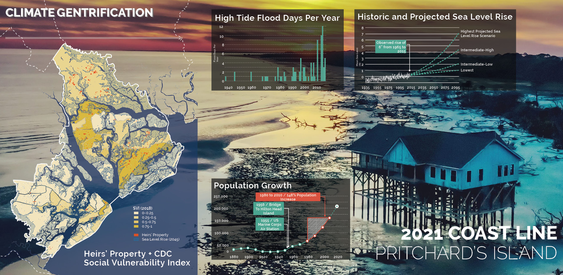
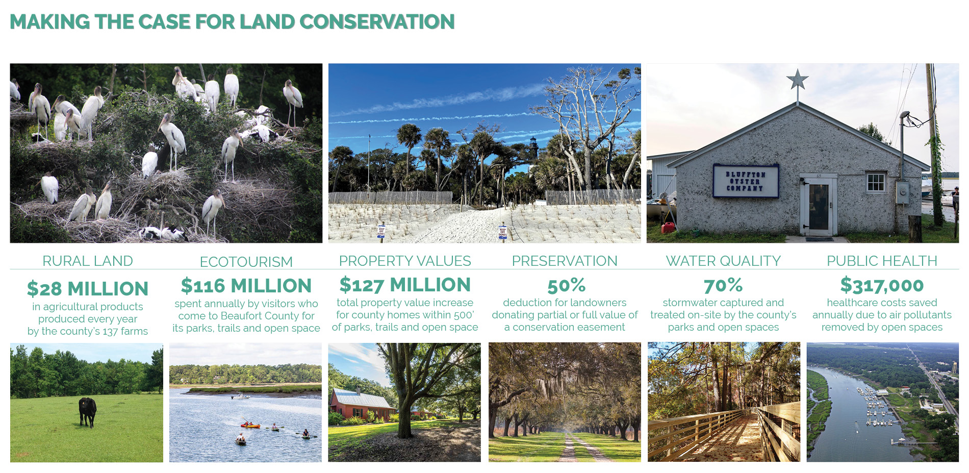
Beaufort County’s unique natural and cultural landscapes, along with its historical built environment, are essential to the county’s sense of place, way of life, ecosystem health and economic sustainability. The combined forces of climate change, sea level rise, growth, and development pressure, will only grow in intensity as sea levels continue to rise and the county’s population continues to grow in unprecedented numbers.
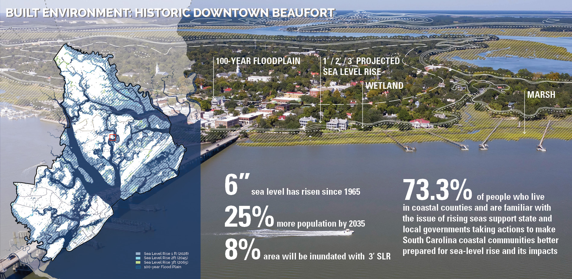
More than half of Beaufort County’s 468,000 acres are tidally influenced rivers, creeks, or marshes. Of the county’s dry land, two-thirds are in a flood zone. Beaufort County is already experiencing the impact of sea level rise in the form of more frequent tidal flooding, and scientists expect local sea levels to rise by another three to seven inches by 2040. At the same time, Beaufort County’s population has skyrocketed and is projected to grow by an additional 125% by 2035.
The Greenprint Plan and Comprehensive Plan creates a framework—informed by community priorities—for data-driven land use planning and open space conservation that balances equity, culture, history, ecology, resiliency and environmentally sensitive growth and place-oriented development. The Plans promote strategies for housing affordability, multimodal transportation, and place-based character.
PUBLIC PROCESS AND THE POWER OF STORYTELLING
Integrating resilience planning, open space planning, placemaking, and growth management had never been done in a cohesive way before in Beaufort County. Showing the interplay between a hazardous future, critical natural environments, appropriate zoning, and growth management was essential to gain acceptance, no easy task in a community generally resistant to land use regulations.
The landscape architect-led team met with stakeholders to develop an understanding of the complex environmental, cultural, economic, and political landscape and the regions historical ecology. The team compiled extensive research on water quality, habitat, and cultural landscape protection in the Low Country to determine the current state and future trajectory of Beaufort County’s ecological and cultural landscapes.
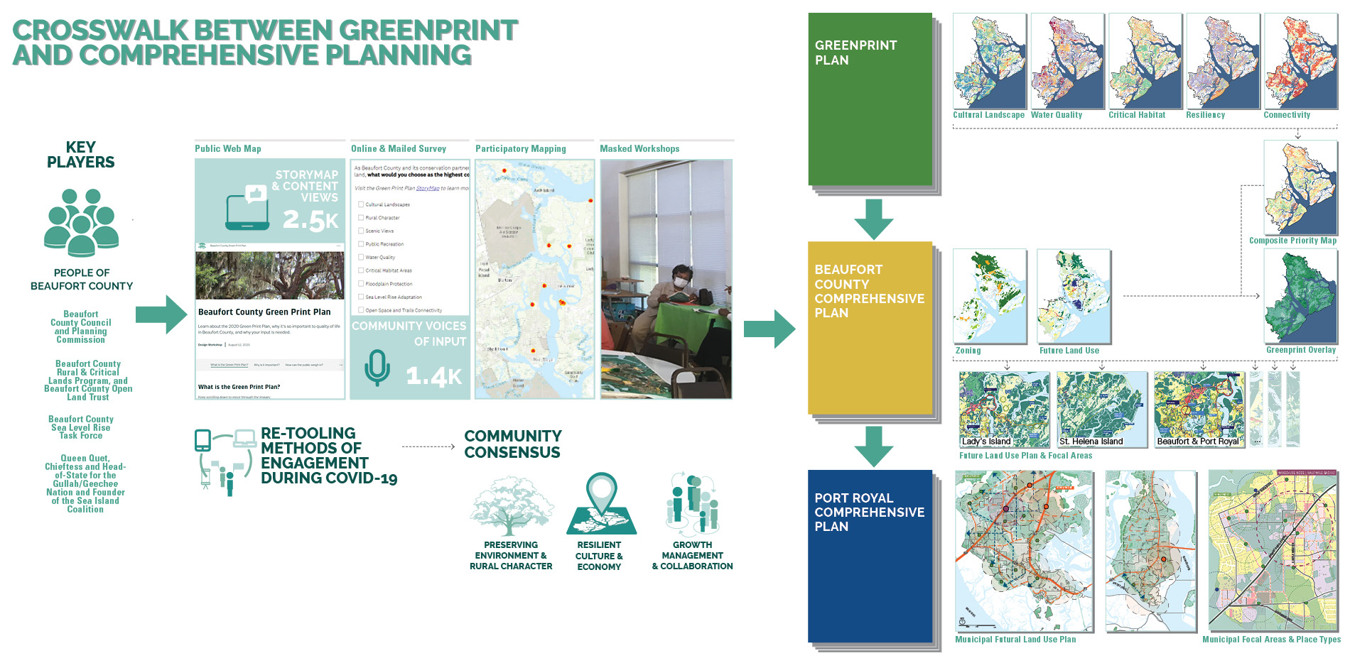
The team then shared that environmental story with the public and invited them to weigh in.an ArcGIS StoryMap used interactive maps and images to walk users through the importance of open space in Beaufort County and introduced a varied toolkit of conservation strategies, educating the public and laying the groundwork for public support of tools outside the county’s traditional methods of land acquisition and purchase of development rights.
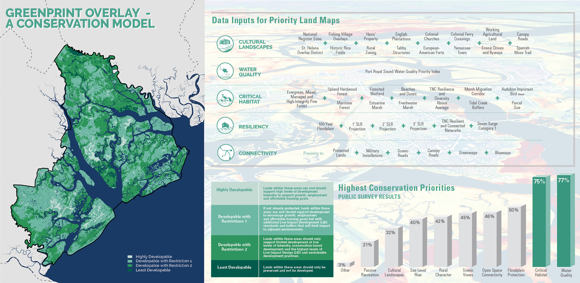
The StoryMap linked to an online survey, completed by almost 1,000 residents in the height of COVID-19 restrictions, that gave the planning team a clear picture of the community’s conservation priorities and the different tools—land acquisition, conservation easements, conservation development incentives, development restrictions—most appropriate to achieve different goals. These preferences were used to inform the Greenprint Plan and the Comprehensive Plan and provide public officials vital steps they can take to protect the county’s ecological and cultural landscapes.
PLACE-SPECIFIC METHODOLOGY FOR RESILIENT HABITATS
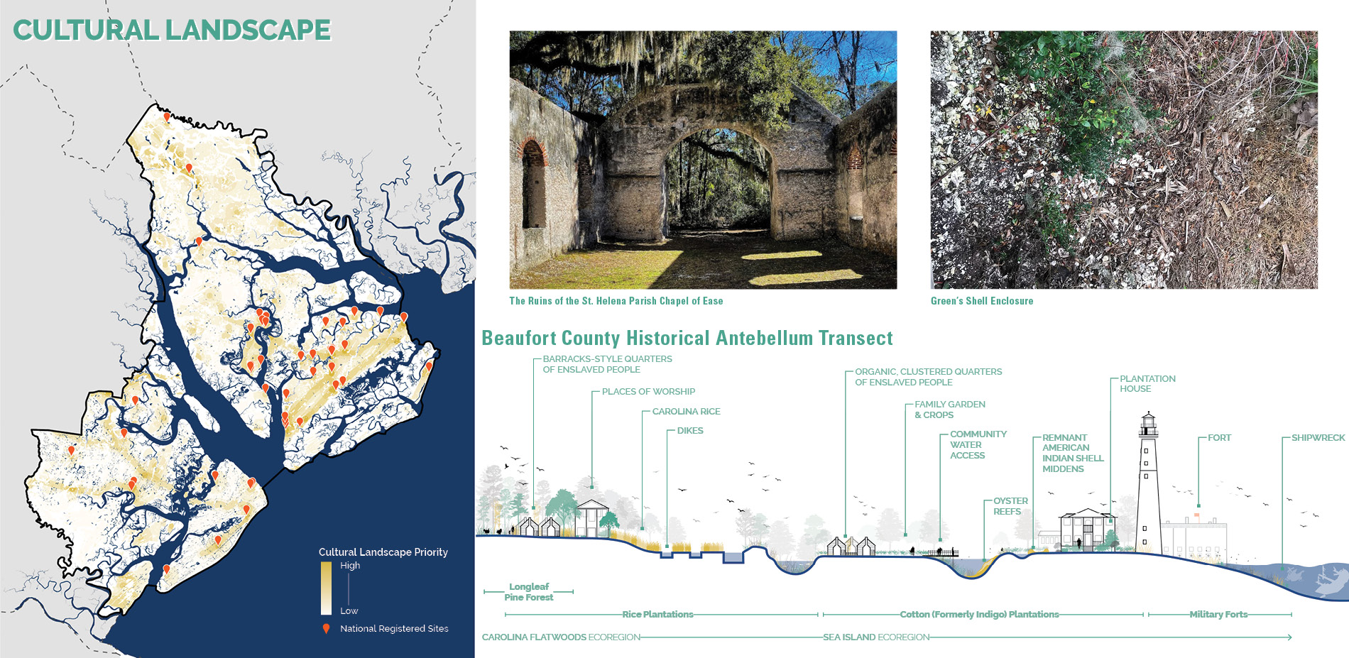
The landscape architect team relied on local expertise to define methodologies for the identification of conservation lands based on the land’s importance to regional ecosystem health, cultural and historic significance, viewsheds, and the immediacy of the threat posed by development and climate change.
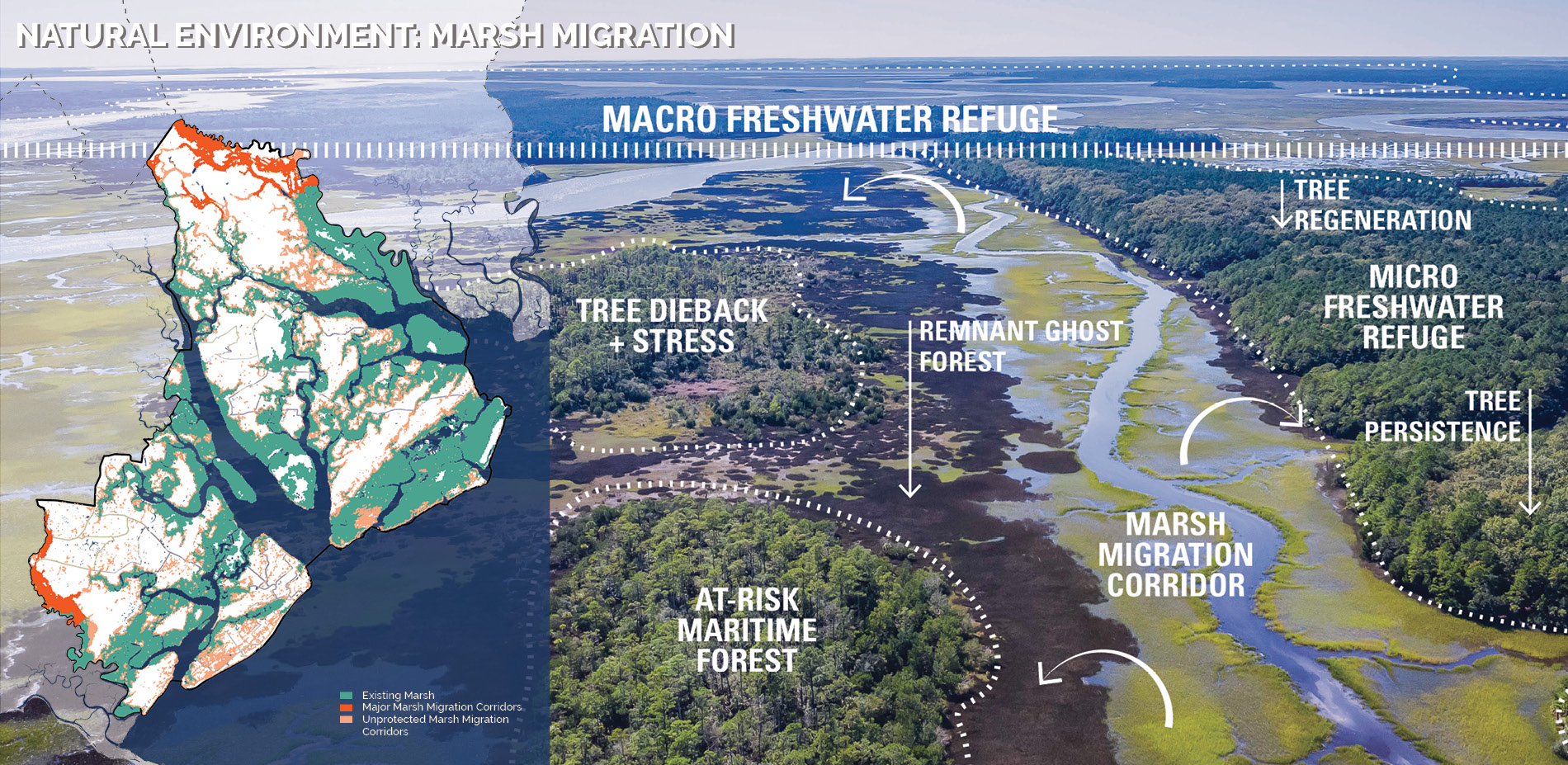
For habitat protection, the plans emphasize higher-elevation lands, given that those areas face greater development pressure; lack other forms of federal and local protection afforded low-lying lands such as wetlands and the floodplain; and will be essential to accommodate future ecosystem shifts—such as marsh migration—precipitated by climate change and population growth.
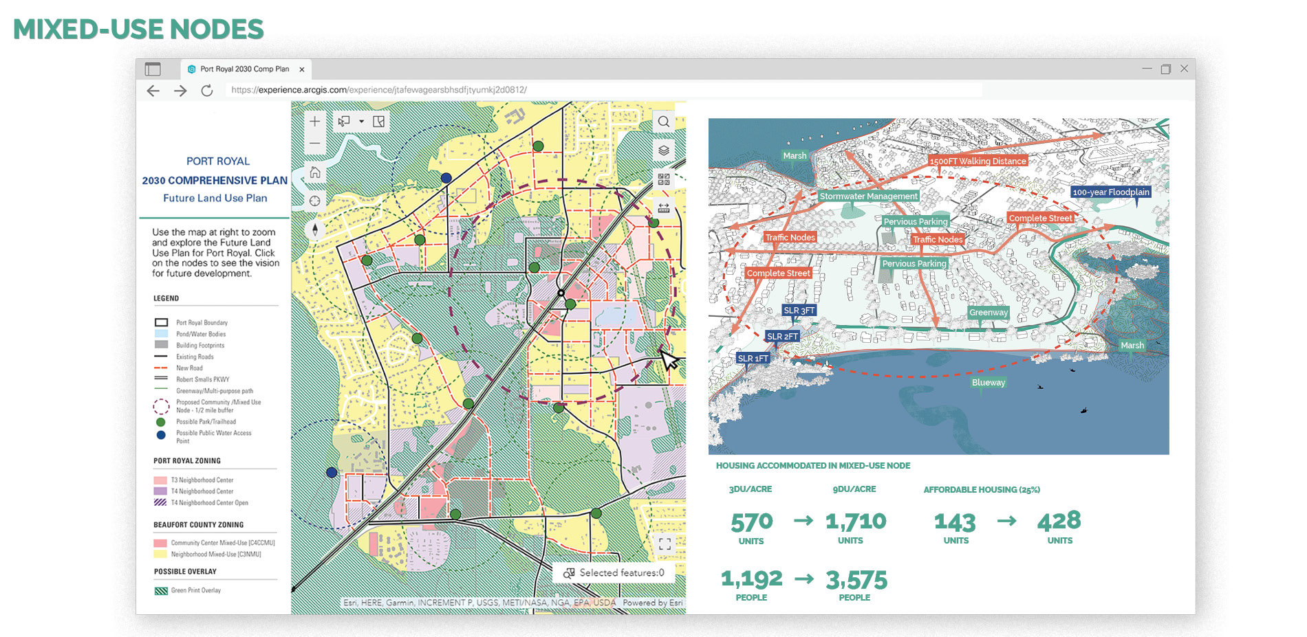
The Plans call for compact transit ready nodes, hamlets, and villages, which reflect upon small town character of the Low Country, and which allow the pine and live oak canopy to be retained at the forefront of the community.
The plans anticipate methods to protect ecosystems and services at a lower cost and seek to avoid displacement by protecting historical communities and heirs’ property, which in Beaufort County is most often undeveloped acreage collectively owned by generations of Black families.
DEVELOPMENT, CLIMATE GENTRIFICATION, AND THE PROTECTION OF CULTURAL LIFEWAYS
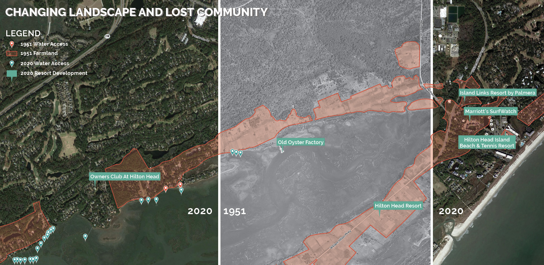
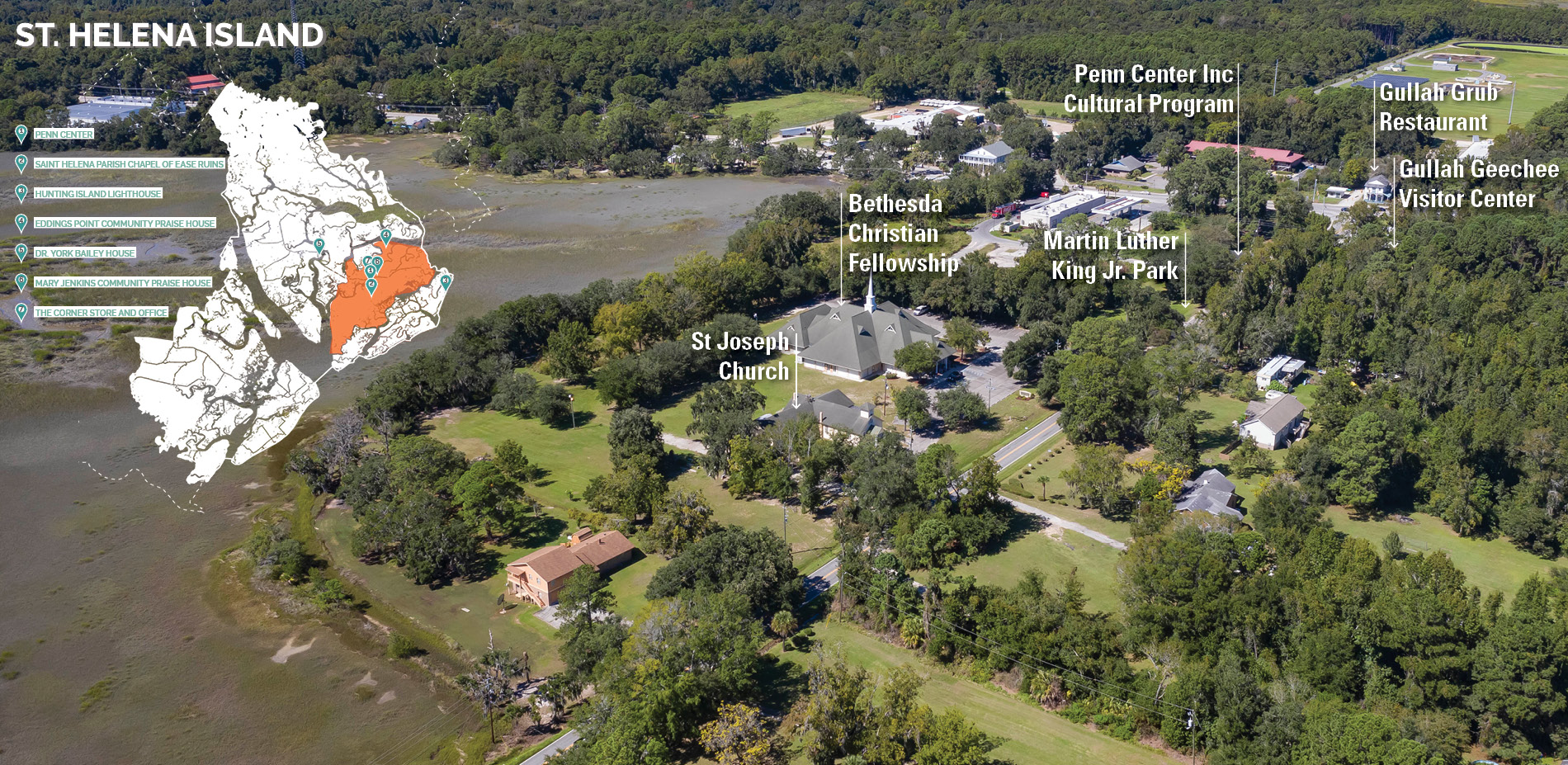
Since the 1960s, many visitors have associated Beaufort County with its long sand beaches and plantation-era ruins. But before the development of Hilton Head Island, Beaufort County was almost entirely rural, and its most historically significant cultural landscape was the communities, waterways, cemeteries, and other landscapes of the Gullah/Geechee.
Development displaced Gullah/Geechee communities, prompting the Gullah/Geechee community of St. Helena Island to develop planning, ordinance, and partnership strategies to prevent the development of golf courses and resort communities there, and to protect their rural heritage and character. Today St. Helena Island faces additional threats of sea level rise, and the growing pressures of developers seeking inland land as part of a trend of climate gentrification.
The landscape architect team worked with the Gullah/Geechee and the Sea Island Coalition to develop a conservation focus that is informed by the protection of cultural lifeways and environmental and cultural preservation. Within the Greenprint Plan and the aligned Comprehensive Plan are recommendations to utilize strategic partnerships, land restoration, development restrictions, tax incentives, special zoning provisions, and educational programs to protect water access, working waterfronts, farmland, scenic views, historic sites, and the properties that have been handed down for generations from original freed slaves (heirs’ property). The expertise of the Gullah/Geechee community informed a mapping methodology and set of strategies that will protect not just Gullah/Geechee sites, but significant cultural landscapes, including tree lined canopy roadways, throughout the county.
TRULY COMPREHENSIVE PLANNING
Comprehensive plans generally silo quality of life and environmental protection elements in separate chapters, rather than considering their realistic integration. They model future land use and growth management irrespective of environmental priorities and conservation goals. This often-shortsighted perspective limits the plan from describing a future that is representative of the intertwined needs of human and environmental ecosystems. However, dynamic environments, where climate change and climate gentrification are happening at a rapid pace, require dynamic tools that find synergies between history, culture, the environment, and economics—now and into the future.
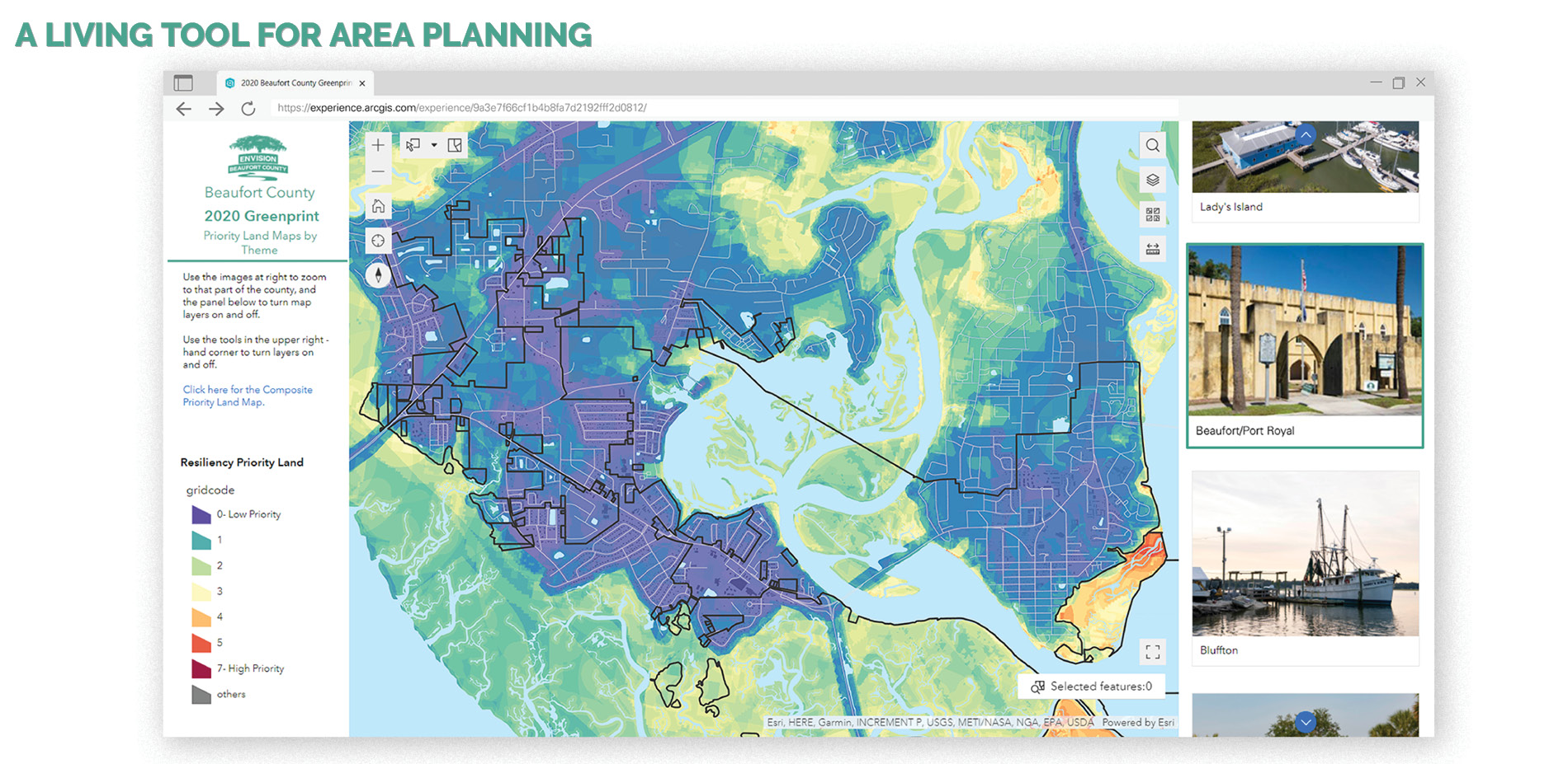
The Greenprint Plan informs the Comprehensive Plan through the recommendation of a Greenprint Overlay derived from a prioritization mapping model, with data inputs and weighting informed by the research and public input collected during the Greenprint planning process. The priority model is a living decision-making tool that aims to map—and highlight—land areas that have overlapping and multiple benefits to the community, within the conservation themes of Cultural Landscapes, Water Quality, Critical Habitat, Resiliency and Connectivity.
The Greenprint prioritization model was built using ModelBuilder in ArcGIS Pro. Conservation priorities can be weighted within each individual theme, and/or across multiple themes, depending on the focus of users. As land areas and priorities change over time, data can be reanalyzed through the model to identify new areas for conservation strategies, new areas for growth, and areas to promote affordable housing.
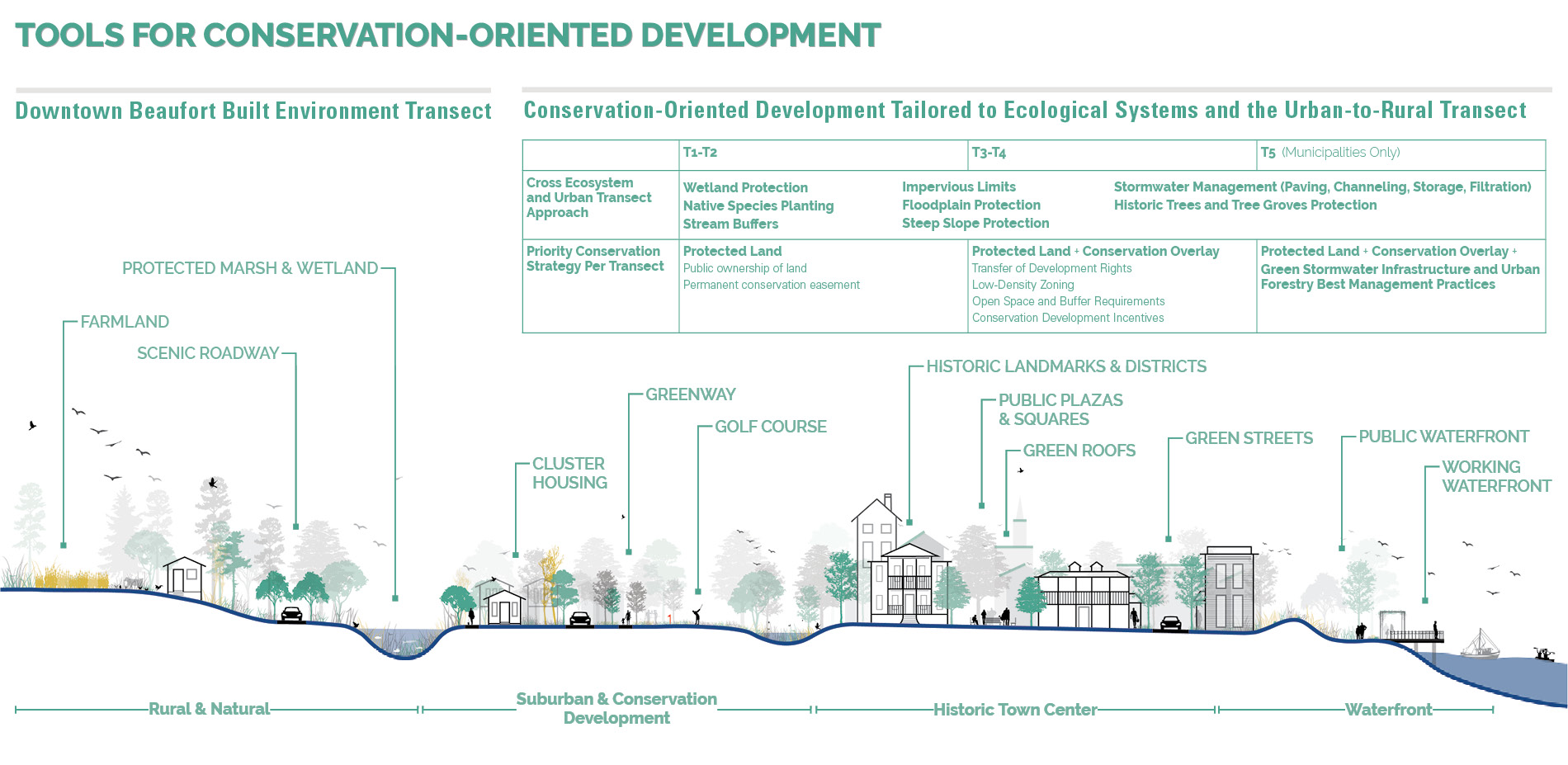
The Greenprint Overlay, which is derived from the composite Greenprint priority land map, adds a conservation lens to view growth management, zoning, and development ordinances by using county-specific ecological and town planning transects to form an integrated matrix that allows local planners to craft conservation, stormwater and growth management goals and policies informed by the intersection of the built environment and Beaufort County ecosystems.
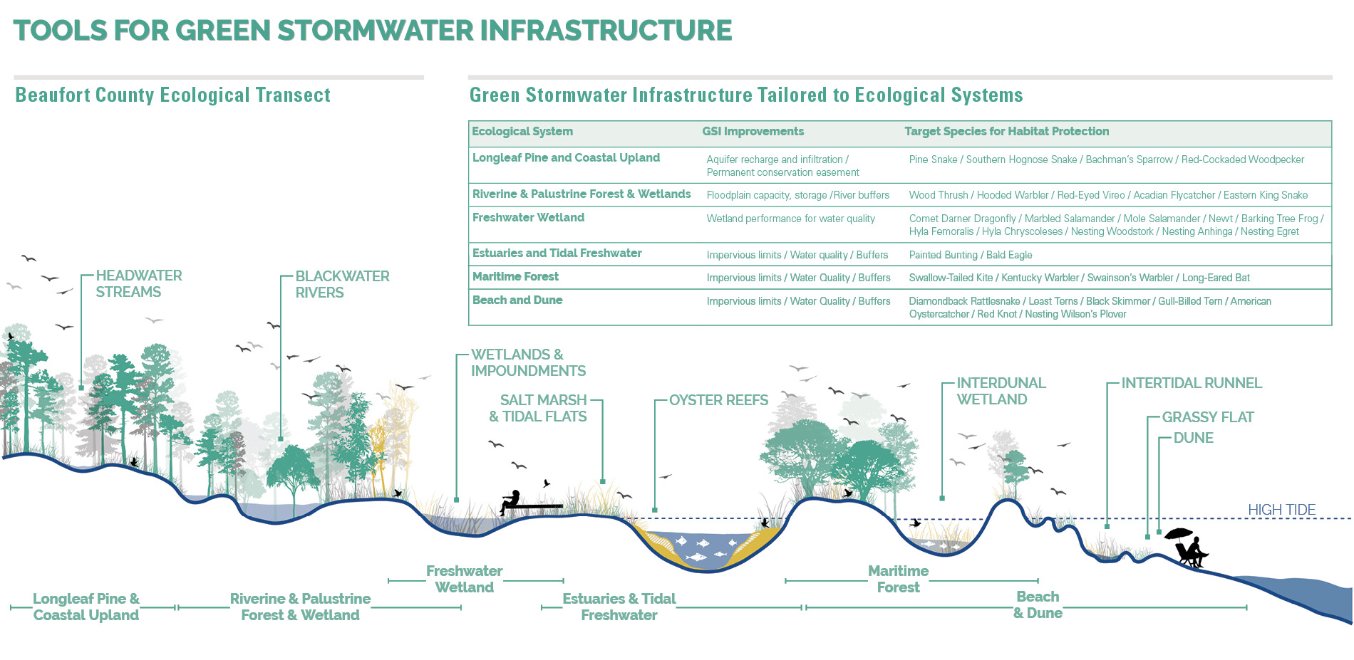
Permanent conservation and land stewardship is concentrated in Rural and Natural Preserve zones. Suburban areas accommodate conservation-oriented development which allow compact pedestrian and bike friendly neighborhood growth while also strategically enabling affordability and protecting critical habitat and ecosystem functions. In urban areas, there are options for promoting ecological health through anticipating future transit ready nodes, Low Impact Development, Green Stormwater Infrastructure, affordable housing, and urban forestry best management practices.
The result is a comprehensive and integrated set of plans that meet the unique needs of the Low Country, while creating a method of planning that can be used in coastal communities across the country.