
At a Glance
- The 2020 Atlantic hurricane season is on a record named storm pace.
- However, it's about to shift into another gear.
- This is due to a number of factors lining up.
- The large majority of strongest hurricanes have occurred from late August on.
The 2020 Atlantic hurricane season, already off to a busy start, is about to shift into a higher gear that could generate multiple storms and hurricanes into early September.
You're probably wondering how the 2020 season can possibly step up.
Last week, Tropical Storms Josephine and Kyle became the earliest tenth and 11th named storms on record in the Atlantic Basin. Kyle formed on August 14, 10 days earlier in the season than 2005's infamous Hurricane Katrina formed, the previous record earliest "K" storm.
We're already more than halfway through the list of 2020 Atlantic storm names.

Using a metric that takes into account not just the number of storms, but also their intensity and longevity, it's been the seventh most active start to an Atlantic hurricane season since 1966, according to Phil Klotzbach, tropical scientist at Colorado State University.
Here are five reasons why this already busy season is expected to turn even more active soon.
1. Tropical Waves Of Note
Plentiful tropical waves are traveling westward off Africa through the tropical Atlantic Basin.
These aren't ocean waves, but rather disturbances of moisture and spin in the atmosphere also known as African easterly waves. According to the National Hurricane Center, they're most numerous from June through August. More importantly, 85% of Category 3 or stronger hurricanes and 60% of all tropical storms and lower-end hurricanes originate from these tropical waves.
A pair of these tropical waves are currently being monitored by the NHC for development this week.

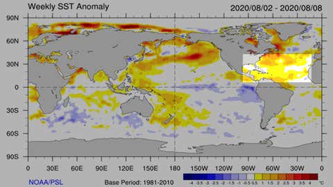
2. Warm Ocean Getting Warmer
Atlantic Basin ocean temperatures typically max out in September or early October after months of heating from the summer sun.
However, ocean water in the Atlantic Ocean, Caribbean Sea and the Gulf of Mexico, is generally warmer than average right now, plenty warm to support stronger hurricanes.
All other factors equal, warmer ocean water provides more instability, heat and moisture for developing and active tropical storms and hurricanes to intensify.
3. Wind Shear Nearing its Seasonal Lull
Wind shear, the change in wind speed and direction with height, is a hostile factor that can rip apart tropical disturbances or adversely affect tropical storms and some hurricanes.
By August, however, wind shear typically reaches its low point in the tropical Atlantic Basin. This is particularly the case in hurricane seasons without a stronger El Niño like 2020 and in the so-called Main Development Region (MDR) from off the coast of West Africa through the Caribbean Sea.
The current analysis shows some modest shear generally north of the Lesser Antilles, but otherwise, rather light wind shear in the MDR where the two tropical waves we're tracking are generally headed.

4. Drier Air Typically Loses Its Punch
Dust-laden air from Africa's Sahara Desert typically surges westward across the Atlantic Ocean multiple times early in the Atlantic hurricane season, providing dry air and wind shear that are both hostile to tropical development.
One such outbreak in late June was the thickest dust plume over the Atlantic's MDR since at least 2003.
These so-called Saharan Air Layers typically peak from late June through mid-August, according to Jason Dunion, a tropical scientist at NOAA's Hurricane Research Division.
As we trend toward September, these dusty intrusions should become less robust and expansive, allowing the air mass surrounding a tropical storm wannabe to become more humid. This is a more favorable environment for tropical storms and hurricanes to develop.

5. Large-Scale Waves Prime the Pump
There are other large-scale atmospheric waves that can energize tropical systems that appear to be in play over the next couple of weeks.
One such wave, known as a convectively-coupled Kelvin wave, is sliding from the eastern Pacific Ocean to the Atlantic Basin right now, according to Michael Ventrice, an atmospheric scientist at The Weather Company, an IBM Business. This wave's upward motion in the atmosphere tends to boost African easterly waves in the Main Development Region, including the pair of disturbances we're watching right now.
Another large-scale wave in the tropics, the Madden-Julian Oscillation (MJO), is expected to align in such a manner that is favorable for tropical development by the end of the month into early September.
"A big burst in activity is usually when the MJO pushes across Africa," said Ventrice via Twitter. This the branch of the MJO with rising air and enhanced thunderstorms.
Ventrice said this rising MJO branch energizes African easterly waves, which then push westward into the Atlantic Ocean and can become tropical storms and hurricanes.
Potentially Dangerous Peak Season is Arriving
According to Colorado State University's Phil Klotzbach, 85% of all Atlantic Basin Category 3 or stronger hurricane activity happens after August 20.
Four of the five most intense mainland U.S. hurricane landfalls have occurred between mid-August and early September.
Last season, 16 of the 18 named storms, 5 of 6 hurricanes, and all three Category 3 or stronger hurricanes happened after August 19.
If you live near a hurricane-prone area, the bottom line is you need to develop or refresh your hurricane plan now, before a storm threatens and also pay close attention to the forecast over the next several weeks.
The Weather Company’s primary journalistic mission is to report on breaking weather news, the environment and the importance of science to our lives. This story does not necessarily represent the position of our parent company, IBM.


